Description: War Thunder is a next generation military MMO game dedicated to...


Many people think that London is the rainiest place in the world. This is not true. In fact, England is not the rainiest country even in Europe. For comparison, the annual rainfall in Moscow is 691 mm, in London - 599 mm. Below is a list of the ten rainiest places on Earth, but several regions claim the title of the most at once, due to different data from different meteorological services.
Kikori is a settlement located in the delta of the river of the same name on the island of New Guinea. The region is notable for its diverse ecosystem, dense forests and a complex network of rivers. Average annual quantity precipitation here is about 5 840 mm.
Andagoya - locality in western Colombia. Known for its equatorial and humid climate, with uniform temperatures throughout most of the year. The average annual rainfall here is 6 817 mm. It usually rains at night.

Lake Henderson (Henderson Lake) - a lake with an area of 14.94 square meters. km. It is located in the southwest of Canada, 3,700 km west of the capital Ottawa, on Vancouver Island in the province of British Columbia. On average, in the vicinity of the lake falls annually 6903 mm precipitation.

The Bellenden Ker Range, also known as the Wooroonooran Range, is a coastal mountain range located on far north State of Queensland, 2 thousand km from the Australian capital of Canberra. It stretches for 65 km and is the wettest area on the mainland. The annual rainfall here exceeds 8 312 mm.

Quibdo is a city located on the Atrato River in western Colombia. Known as the rainiest place in Latin America and one of the wettest regions of our planet. On average, it falls here 8 989 mm precipitation per year.

Debunja is a village in Fako department, Cameroon. It is located on the southwestern slope of the active volcano Cameroon, in the southwestern region of the republic. This village is average annual quantity precipitation 10 299 mm ranked fifth in our rankings.

Waialeale is a volcano located in the heart of the island of Kauai, Hawaiian Islands. On its slopes, on average, falls 11 684 mm rainfall, and special climatic conditions contribute to the development of lush vegetation. Due to frequent rains, the top of the volcano is almost always hidden either in thick fog or haze.

Cherrapunji is a small town in Indian state Meghalaya. It is located on the Shillong Plateau, north of the border with Bangladesh at an altitude of 1313 m above sea level. Along with the village of Mavsynram and the city of Lloro, it is the rainiest and wettest place on Earth. Falls here every year 11,777 mm precipitation.

Mawsynram is a settlement located at an altitude of 1400 m above sea level in the north-east of India, 16 km west of Cherrapunji. This village, along with the city of Lloro and Cherrapunji, is considered the rainiest place in the world. Falls here every year 11 872 mm precipitation.

Lloro is a municipality and city in Colombia. Estimates based on records meteorological station, established in the city, this area holds the absolute record for the amount of precipitation in the world - on average 13 300 mm in year.
Share on social networks
Live and learn. Especially when the world is changing so fast. And if the most high point and the coldest place on the planet is known to almost everyone, then who can immediately say which object is photographed most often? Or in which country do they drink the most coffee?
 BUT The Snow Queen definitely lives here - at the Vostok station in Antarctica. Here is the best: August 10, 2010 the temperature was as much as -89.2 °C. Wrinkles will definitely not appear.
  Of course, in China, but where else? in Shanghai on this moment more than twenty-four million inhabitants.
  The Vatican City State has only 842 inhabitants, and only about 600 of them have citizenship. The fact is that it is not enough just to be born there, a real citizen must also serve the church. So the remaining 200-odd people have resident status.
  It is possible that this tower in Tokyo is actually made of gold, because it is the wealthiest city on Earth at the moment.
  the capital of the poor country on the planet - the Democratic Republic of the Congo - is the poorest city on Earth. In Kinshasa, many residents live on $1 a day.
  Geography, fifth grade, and still impressive! The legendary Everest on the border of Nepal and China is as high as 8,848 meters above sea level.
  Challenger's Abyss Mariana Trench not entirely bottomless. It's just that the bottom is very deep, about 10,916 meters below sea level.
  And this is not a mirror at all, but the Guggenheim Museum. Still, not everything is lost for mankind: we love museums no less than ourselves.
  In the village of Mawsynram in India, there is no such thing as a rainy season, because it pours like a bucket, almost all year round. For example, in 1985 more than 2500 mm of precipitation fell there - an absolute record. For comparison, in Moscow, on average, only 700 mm falls per year.
  You will be surprised, but this is not at all some kind of sultry desert. The McMurdo Dry Valleys are located in Antarctica. Winds here reach speeds of up to 320 km / h, which causes constant evaporation of moisture. Some areas of the Dry Valleys have not seen rain or snow for two million years.
  It will be difficult without sunglasses in the city of Yuma, Arizona in the USA. The sun shines here for 11 hours a day, and cloudless weather lasts almost the entire year. So over 4000 hours run in a year daylight hours and clear skies.
  Translated into our money, a modest Toyota Prius will cost you more than seven million rubles in Singapore. What can we say about the prices of bread, which you can buy here for no less than 120 rubles? This metropolis has overtaken even Tokyo and London.
  Services, food, rent, transport - everything is very cheap in Mumbai. But such comfort and cleanliness as in Singapore cannot be obtained here. As they say, take your pick.
  You won't have to think long: in the USA, the daily calorie intake is 3,770 per person.
  Irian Damascus has existed for eleven thousand years, and all this time people have been living in it. This is real old stuff.
  Inhabitants South Sudan consider themselves citizens independent state since July 9, 2011.
  After several years of bitter struggle with Bangkok, London finally snatched victory and now proudly bears this title. More than 18 million guests from different countries come here every year.
  According to the BBC rating, the most positive people from all over the world speak about Germany. Apparently, the brutal appeal of the Germans and beer with sausages are doing their job.
  At the other end of the list is Iran, with only 15% of people leaving positive feedback about this country.
  There are an average of three murders every day in San Pedro Sula in Honduras. And buying drugs or weapons there is like brushing your teeth.
  Even with a large influx of tourists, Tokyo steadfastly holds the position of the safest and most clean city on the planet. And taxi drivers in Tokyo have a reputation for being the friendliest.
  And how do the Swedes manage to stay so calm when there are almost 400 mg of caffeine per person per day. That's almost five cans of Red Bull.
  No, not Amsterdam, and not Copenhagen. A small Groningen in the Netherlands. Here, half of the movements in the city are made by bicycles. But in the famous capitals, only a third.
  While we're talking about rising gas prices, Reykjavik lives quietly on energy from geothermal sources, and they run hydrogen-powered buses around the city. By 2050, Iceland plans to completely switch to non-fossil energy sources.
  And again, Japan is ahead of the rest. This country is ahead of the rest in the number of cat cafes where people can dine and spend time with their pets. Also in Japan there are as many as two “cat islands”, where these animals have practically captured the entire territory, calmly roaming the streets and enjoying a carefree life.
  France loves dogs the most. Here you can go with your dog almost anywhere. public place. In a restaurant, your four-legged friend will even be offered a bowl of water. And among pet owners, more than half keep dogs.
  In Switzerland, sex education begins as early as kindergarten. And given the liberal views on pornography and prostitution, the majority of the country's population considers their sex life "excellent." By the way, Switzerland is also number one in the list of countries with the lowest teenage pregnancy.
  Unfortunately, in Japan, only 15% of residents noted that they are completely satisfied with their intimate life. But 45% of women generally said that they were not interested in sex.
  In Monaco, people live long and tastefully. Men - on average up to 85 years, and women - up to 89.
  “Live fast, die young” is about Sierra Leone. Here, men and women barely live up to 48 years.
  Spain is slightly ahead of Germany in this ranking. Almost ninety percent of Spaniards have nothing against sexual minorities.
  Archbishop Peter Jasper Akinola of Nigeria backed a law against homosexuality. Now in this country, people of a non-traditional orientation are not only "white crows", but also outside the law.
  Disputes about this will never stop, because everything is very subjective here, but at the moment for men - this is Brazil. It is understandable, in principle.
  But women find Australians wildly attractive.
  Taking into account indicators such as the murder rate, unemployment, corruption and incomes of the population, the statistics show that Nigerians are the hardest hit.
  On the other hand, Norwegian life is considered the least stressful, more balanced and prosperous.
 Oddly enough, the wettest and most dry place on the ground are adjacent to each other and located on different sides mountain range. AT South America.
Approximately 80 million years ago, volcanic eruptions began to shake the South American continent, which continues to this day. Under the influence of shifts that occurred in the depths earth's crust, along the entire length of the mainland rose the longest mountain range on Earth - the Andes. The mountains stretch for 8 thousand kilometers. The peaks are so high that even at the equator they are covered with snow and ice.
The high slopes of the Andes have created entirely new natural areas on the continent. This gigantic barrier changed the climate of South America and corrected the map of the entire continent by causing the main rivers to flow eastward.
One mighty river now irrigates 40% of the territory of South America. This is the Amazon largest river on the ground. From the Andes to the Atlantic Ocean, it travels more than 6.5 thousand kilometers, carrying 1/5 of the entire river water our planet. 1.5 thousand kilometers before joining the ocean, its main channel is more than 15 kilometers wide. An interesting fact: not a single bridge has been built across the Amazon.
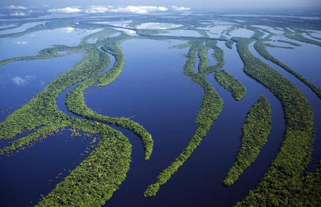
Every year the great Amazon overflows its banks, flooding forests in an area the size of England. At the peak of the flood, the trees can be immersed in water by 10 meters.
The Amazon and its tributaries irrigate the largest a tropical forest on the ground. The Amazonian jungle covers the space from the Andes to the Atlantic with an almost continuous carpet and is the wettest place on earth.
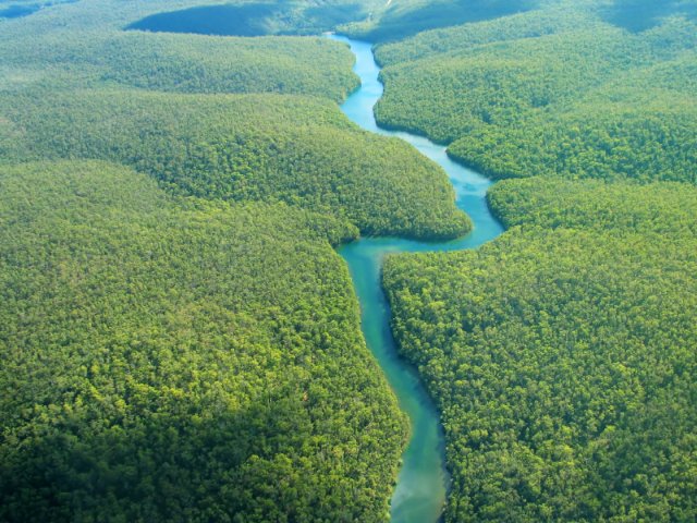
The Amazon lies to the east of the Andes, and powerful tropical rains pour over the jungle, feeding it with water. But the mountains serve as an obstacle to the winds that carry moisture from the east, so that there are places on the western side of the mountains where not a drop of rain falls. Here is the driest desert in the world - Atacama. This is a narrow strip between the mountains and the Pacific Ocean. The Atacama may not have rain for several years and the humidity level is zero. It's hard to imagine how you can survive here, but some people manage to do it. The pledge of life for the desert is the Pacific Ocean. Every morning a blanket of fog spreads over the desert, Pacific Ocean. Fog is almost the only source of water in the desert. This moisture condenses in the early morning on the spines of cacti and on lichens growing on cacti. This water is the only life-giving moisture for the selfless inhabitants of the Atacama. There is no more water in the desert.

Atacama is one of the most unusual places on the planet - Moon Valley (Valle de la Luna). This place will resemble the lunar surface due to the unique formations of salt, sand and stones scattered several million years ago by a nearby volcano. In the valley you can watch amazing lifeless landscapes and sunset unearthly beauty, which delights with its range of colors. This is where many science fiction films were filmed.
[:RU]One of the most amazing features of our planet is the presence of completely dissimilar climatic conditions in different places, as if we live on different planets. The planet's distance from the Sun, as well as the 23.5 degree tilt of the Earth's axis, contribute to differences in climatic conditions in many places on Earth, especially those located farther from the equator. However, some places on Earth don't experience much climate change at all. Year after year, residents of these areas see the same weather day after day.
In terms of the areas that receive the most rainfall per year, many of them are located near large bodies of water or mountains. Most of the rainiest places on earth are in close proximity to mountains and other highlands that channel clouds, trap permanent clouds that eventually release moisture as precipitation. Because of this phenomenon, half of the wettest places on Earth are in Hawaii or located in the northeastern part of India.
10. Emei Shan - China - 8169 mm

The rainiest place in all of China, Emei Shan is located in the Sichuan province in the south-central part of the country. In 1996 the place was listed world heritage UNESCO, as Mount Emeishan is located here, which is the highest of the four sacred mountains of Buddhism.
9. Cookies - Hawaii (USA) - 9293 mm

Cookie is a place on the island of Maui, Hawaii, where there is a mountain peak that rises to 1765 meters above sea level, and which was formed as a result of the explosive force of the volcano many years ago. The eruption also created the Mex Valley, which is the wettest area in Hawaii these days. Due to its natural value, diversity of flora and fauna and beauty, the area is considered a nature reserve.

Waialeal receives so much rain every year that the ground is a constant mixture of mud, which in turn makes mountain hiking here extremely dangerous even for the most experienced hikers.
Waialeale in Hawaiian translates as "overflow of water", which is quite logical, given the abundance of rainfall.

Recently, after ten years of studying the distribution of precipitation in Hawaii based on data collected at a weather station located in 1992, a large swamp located in the territory national park Haleakala has been called the rainiest place in Hawaii. This claim is controversial due to the difficulty in collecting data in the area and because of its remoteness.
However, the big swamp is a major tourist attraction for those seeking to immerse themselves in some of the most beautiful, green places that adorn our planet.

Debunja is a village located in the southwestern outskirts of Cameroon, in the South Atlantic Ocean on the coast of this African country. This area, the second wettest on the African continent, was part of a German colony in the early 20th century. The Germans left behind a lighthouse that stood for more than 100 years.
Debundja receives most of its rainfall due to its coastal location and proximity to Mount Cameroon. This mountain accumulates dense cloud formations that allow huge amounts of moisture to fall.

The wettest place on the African continent is San Antonio de Ureca, a city located in Equatorial Guinea, an island nation not far from the slightly less rainy village of Debunja. San Antonio de Ureca is located in the southwest of the island, overlooking the Atlantic Ocean, slightly north of the equator. Most days of the year it rains heavily.

Located along the western part of New Zealand, near the Tasman Sea, the Cropp River flows through the highlands, which contributes to a sharply increased level of rainfall. Between October 1997 and October 1998, the Cropp River valley received an incredible amount of rainfall - 18,413 mm.

The small village of Tutendo, with a population of less than 1,000, has the reputation of being the rainiest place in South America. All homes in this region are waterproof to keep indoors dry. Even during the driest season from February to March, it rains 20 days a month.

Less than 16 kilometers from the official wettest place on Earth, is the Cherrapunji region, where it's raining almost daily. The Guinness Book of World Records states that this region holds the record for the most rainfall in a single month, with 9,300 mm of rainfall in July 1861.

The argument that the region is the wettest place on earth is that Mawsunram receives an average of 94mm more rainfall than Cherrapunji, which is about 0.7 percent more.
To dampen the noise of the incessant rain, many residences are lined with thatched roofs to absorb the impact of the constantly falling water droplets.
However, you don’t want to go on vacation to such places at all. In our climate with a constant lack of heat and sunny days to rest, you want to get closer to the sunny seashore to ride on a luxury yacht. Yacht charter in Montenegro will be the best way understand what is real sea travel, get a lot of positive emotions, make your vacation exciting and romantic.[:]
As you know, the Sun on Earth shines for everyone - however, not always with the same intensity warming us with its warmth. But if the cold periods are nevertheless replaced by warm ones, then the distribution of water precipitation is devoid of even the semblance of some kind of justice.
There are places in the world where heavy rains pour literally every day, forcing the locals to suffer from high humidity. Where is the wettest place on earth?
According to the Guinness Book of Records, the wettest and rainiest place on our planet is in India. It is located in the state of Meghalaya, on one of the slopes of the East Khasi mountain range. This is the town of Mawsynrem, in which there is even a special sign indicating that the rainiest and wet place on the globe is right here.
During the year, 11870 mm of water pours onto the roofs of Mausynrem. Is it a lot or a little? If the 38-meter statue of Christ from Rio de Janeiro stood in Mausinrem, then the water collected during the year would reach the knees of Jesus.
The name of the town in translation means "land of clouds", as it is very often, especially during the monsoon season, which lasts from June to September, dense clouds reign. Constantly high humidity quite annoying at this time local residents who, however, have learned to deal with the weather.
During the rainiest season, the inhabitants of the city throw a kind of umbrellas over their heads and shoulders, which are woven from thin bamboo shoots and wide leaves of a banana tree. They cover the roofs of houses with thick layers of straw so as not to be annoyed by the constant sound of falling drops.
Distinctive feature Local places that attract tourists along with the rainy climate are the so-called "living bridges" from the roots of rubber trees. These bridges, thrown over rocky clefts or over small rivers, not only do not collapse over the years, but, on the contrary, become even more durable.
They are “built” as follows: they throw a light bridge of bamboo poles across the river and braid it with the roots of rubber trees. A year or two later, the bamboo humid climate completely rots, but the roots braiding it during this time are strengthened and grow thanks to generous rain watering.
Further maintenance of the bridge consists in periodic trimming of the roots, which every year strengthen the light hanging structure more and more.

In the Indian state of Meghalaya, which is located on the Shillong Plateau, north of the border with Bangladesh, there is the rainiest place on the planet: Cherrapunji. Meghalaya means "shelter of the clouds" in Sanskrit. The city of Cherrapunji is located at an altitude of 1300 m above sea level, in the picturesque mountains of Khasi. It lies on the path of the monsoons coming to India from the southwest, right in the middle of the labyrinth of mountains, which forms a kind of funnel here from the incoming clouds.

The average rainfall in this area is 11.43 meters per year, that is, about three centimeters daily. But the record number fell in 1861 - 22.98 meters. Despite this fact, the tribal name of this place is Sohra, which in translation from the Kashmiri language means "infertile, barren". And when you turn onto the road leading to the town, you will realize that the Kashmiris were not joking - the landscapes around Cherrapunji are exactly reminiscent of views from westerns. The road stretches along the desert plain, and is interrupted only by groups of monolithic stones erected by the tribal people as an offering to the Gods for each newborn.
Residents of the city of Cherrapunji recall 1994, when a record rainfall of 24,555 mm fell on the tiled roofs of their houses. However, do not think that heavy clouds hang over this city all year round. When nature softens a little, and a bright sun rises over the surroundings, an amazingly beautiful rainbow hangs over Cherrapunji and the surrounding valley.

From time to time, the mountainous terrain is replaced by deep canyons. The cut in the ground is so stunning that during the dry season it is difficult to imagine what this place looks like in the rainy season, when the rain flows into the sea, jumping over high gorges. After heavy rains, the bottom of the canyon is dotted with dense vegetation several meters high.
Life in this place can be defined as follows: five months of almost continuous showers are followed by seven months of a hot dry season. Pakistanis and Indians have found a way to survive and manage such harsh natural conditions. Perhaps one of the most interesting adaptations is growing "living bridges from tree roots". These bridges are made from the roots of a special tree, guided along a certain wire frame until they take the form of a bridge. Such a process can take up to 25 years, and besides, it requires constant care and attention. Due to the mountainous desert terrain, such bridges can be found mainly at the bottom of canyons or in the forest.
Description: War Thunder is a next generation military MMO game dedicated to...

"Titan Siege" is a large-scale online game on the theme of Scandinavian and ancient Greek...

Being an avid lover of German tank looks, I spent a lot of time...